Kīlauea erupts for 49th time, captured by GOES-18 satellite
Key Takeaways
- Kīlauea's 49th eruption sent lava 700 feet into the air on June 14, 2026
- The GOES-18 weather satellite captured the eruption in thermal imagery from space
- USGS predicts the 50th eruption between June 24-29, most likely June 25-26
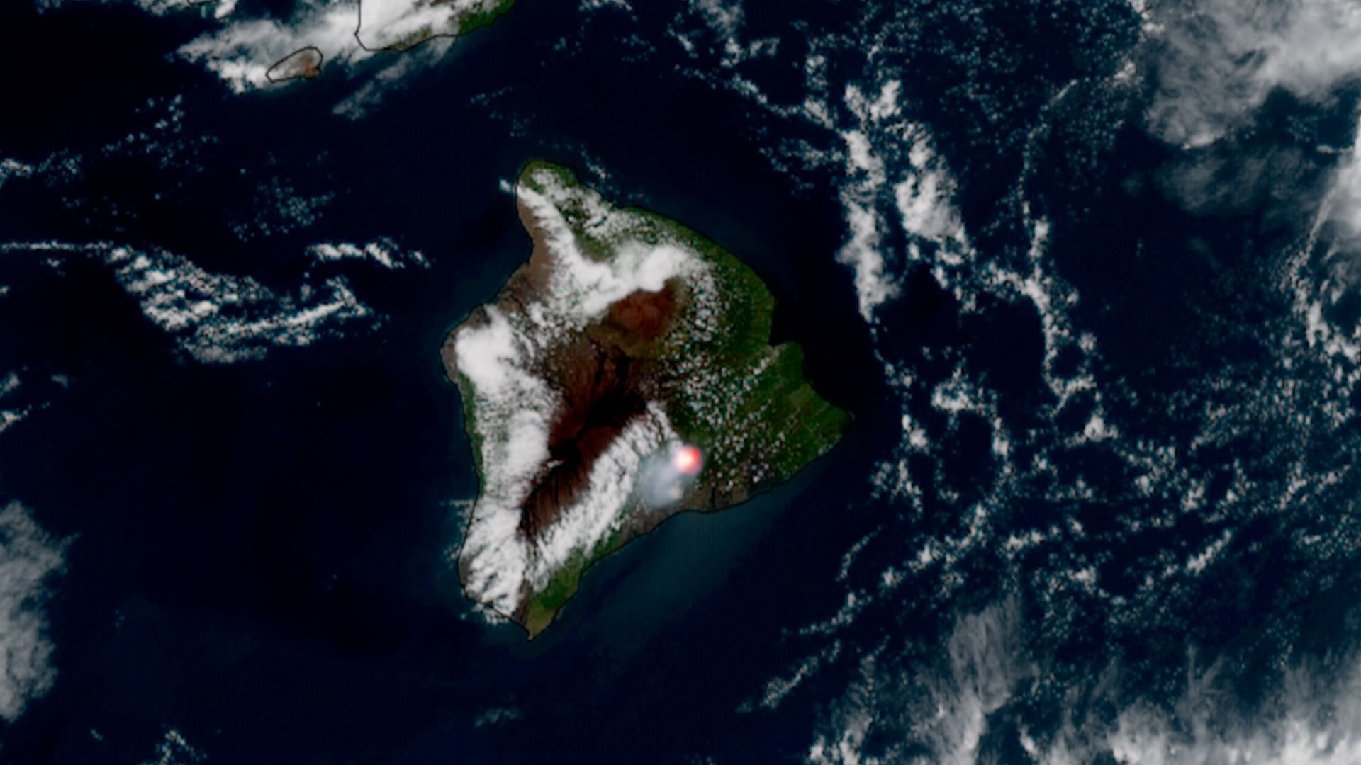
Hawaii's Kīlauea volcano erupted for the 49th documented time on Sunday, June 14, 2026, shooting lava fountains roughly 700 feet into the air. The GOES-18 weather satellite caught the event, producing thermal imagery that shows the eruption as a bright red hotspot on the Big Island.
The eruption lasted about seven and a half hours, according to the U.S. Geological Survey's Hawaiian Volcano Observatory. No lava escaped the caldera, but three earthquakes struck within the Kīlauea caldera during the event.
What does the satellite imagery show?
The GOES-18 footage, shared by NOAA and Colorado State University's Cooperative Institute for Research in the Atmosphere (CIRA), compresses over seven hours of observation into a short gif. The bright red spot toward the bottom right of the island indicates intense heat from the lava fountains, per the thermal scale in the imagery.
The captured timespan runs from 3:01 p.m. EDT (1901 UTC) on Sunday to 10:31 p.m. EDT the same day (0331 UTC the following day). The animation shows the hotspot intensifying and then cooling as the eruption concluded.
Why Kīlauea matters more than most volcanoes
Kīlauea is considered the most active volcano on Earth. It has erupted consistently for roughly 200 years. The volcano's summit rises 4,090 feet (1,250 meters), and its caldera spans about 3 miles long and 2 miles wide. That caldera contains Halemaʻumaʻu crater, the source of the volcano's eruptions.
This 49th episode began after approximately five hours of precursory lava overflows from the north vent, starting at 4:10 a.m. HST on June 14. Several subsequent overflows from both north and south vents followed before the main fountaining event.
When is the next Kīlauea eruption expected?
The USGS has already issued a forecast. Episode 50 is predicted to occur between June 24 and June 29, with June 25-26 being the most likely window. Kīlauea's frequent activity makes it one of the most predictable volcanoes for scientists to study.
How weather satellites track natural disasters
The Kīlauea footage demonstrates the versatility of weather satellites beyond forecasting. GOES-18, primarily designed for meteorological observation, can monitor volcanic activity, wildfires, and other natural disasters in near real-time. This data helps scientists assess hazardous areas and coordinate relief efforts when needed.
Satellite imagery becomes more valuable as climate change intensifies. Global warming correlates directly with increases in hurricanes, cyclones, and wildfires. More satellite observation capacity means better monitoring of these escalating events. The same satellites have previously captured everything from penguin colonies to solar eclipses to rocket explosions.
Frequently Asked Questions
How high did the lava fountains reach during the Kīlauea eruption?
The lava fountains reached approximately 700 feet (210 meters) into the air during the June 14, 2026 eruption.
How long did the Kīlauea eruption last?
The eruption lasted about seven and a half hours, according to the USGS Hawaiian Volcano Observatory.
When is Kīlauea expected to erupt again?
The USGS forecasts the 50th eruptive episode between June 24-29, 2026, with June 25-26 being the most likely dates.
Did lava flow outside the Kīlauea caldera?
No. While lava fountained 700 feet high, no lava was reported exiting the caldera territory during this episode.
What satellite captured the Kīlauea eruption from space?
The GOES-18 weather satellite, operated by NOAA, captured thermal imagery of the eruption showing the volcano as a bright red hotspot.
Logicity's Take
Kīlauea's predictable eruption schedule, now averaging roughly 10-14 days between episodes, makes it a natural laboratory for testing satellite monitoring systems. The GOES-18 thermal detection that worked for this contained eruption is the same technology that would provide early warning for more dangerous volcanic events elsewhere. As eruption prediction improves, the limiting factor shifts from detection to evacuation logistics.
Need Help Implementing This?
Stay updated with the latest developments in space observation, earth sciences, and technology by subscribing to Logicity's newsletter. Follow us for daily coverage of the stories that matter to tech professionals.
Source: Latest from Space.com
Manaal Khan
Tech & Innovation Writer
Related Articles
Browse all
NASA April 2026 Satellite Puzzler: Can You Identify This Mystery Location from Space?
NASA's Earth Observatory just dropped their monthly satellite image challenge, and it's your turn to play detective. The April 2026 puzzler asks readers to identify a mystery location using nothing but clues visible from orbit. No prizes except bragging rights, but honestly, that's kind of the point.
AI-Powered Solar Cell Factory Hits 27.22% Efficiency: How Machines Are Now Inventing Better Materials
Researchers have built an autonomous system that discovers new materials AND manufactures solar cells with almost no human involvement. The AI-driven platform achieved a record 27.22% efficiency and proved nearly 5 times more consistent than human workers. This could fundamentally change how we develop clean energy technology.
Research Librarians Are Research Partners: Why Universities Need to Stop Treating Them Like Help Desks
A new Nature correspondence argues that academic librarians bring genuine disciplinary expertise to research teams, not just search skills. The piece pushes back against the outdated view of librarians as mere service providers, highlighting examples where librarians have contributed as co-authors on peer-reviewed studies.
Deep-Sea Mining Rules 2026: Why NOAA's New Fast-Track Process Has Scientists Worried
The US National Oceanic and Atmospheric Administration just made it easier for companies to apply for deep-sea mining permits, combining exploration and commercial mining into one streamlined process. But here's the problem: we still don't have basic environmental data about what's down there, and the International Seabed Authority hasn't even finalized its Mining Act yet.