NASA April 2026 Satellite Puzzler: Can You Identify This Mystery Location from Space?
Key Takeaways
- NASA Earth Observatory releases monthly satellite image puzzles for the public to solve
- The April 2026 challenge is now live and accepting submissions
- Winners get recognition when the answer is revealed about a week later
- You can submit guesses or go deep with details about the satellite, spectral bands, or geological features
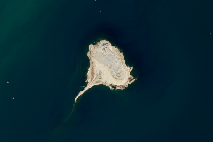
So NASA wants you to stare at a satellite image and figure out where on Earth it was taken. That's the premise behind the Earth Observatory's monthly Satellite Puzzler series, and the April 2026 edition just went live. It sounds simple enough, right? But once you actually zoom in and start looking for clues, things get surprisingly addictive.

What Exactly Is the Satellite Puzzler?
Every month, NASA's Earth Observatory team picks a satellite image and strips away all the context. No labels, no coordinates, no hints about what you're looking at. Your job is to figure out the location based purely on visual clues. Think of it as GeoGuessr, but way nerdier and with actual space imagery.
The challenge has been running for a while now, and it's built up a pretty dedicated following. Some people just take a quick guess based on gut feeling. Others go full detective mode, analyzing geological formations, vegetation patterns, coastline shapes, and even the specific coloring that reveals which spectral bands were used to capture the image.
How to Submit Your Answer
Head to NASA Earth Observatory's website and use their submission form. Select 'Puzzler Answer' as the topic, include your preferred name or alias, and share your guess. You can keep it simple or go all-in with technical details about the satellite, instrument, and spectral bands used.
What Are You Actually Looking For?
Here's where it gets interesting. The image could be anywhere on the planet. Literally anywhere. So you need to start noticing things most people would scroll right past.
- Coastline shapes and water body patterns
- Mountain ranges, valleys, or distinctive geological features
- Vegetation colors (greens, browns, seasonal changes)
- Urban development patterns or agricultural grids
- Color shifts that hint at specific spectral bands (infrared shows vegetation differently)
- Cloud shadows and their angles (can reveal latitude and time of day)
- River systems and their drainage patterns
The real pros will even identify which satellite captured the image. Was it Landsat? Sentinel-2? One of the commercial imaging satellites? Each has its own resolution and spectral capabilities, so if you know your satellites, you can narrow things down fast.
No Cash Prize, But That's Not Really the Point
Look, NASA isn't going to send you to space or write you a check. They're pretty upfront about that. But they will give you something that honestly matters more to the kind of person who enters these challenges: recognition.
“We can't offer prize money or a trip to space to see Earth like satellites and astronauts do. But we can offer something almost as rewarding: puzzler bragging rights.”
— NASA Earth Observatory
About a week after the puzzler goes live, NASA posts the answer along with an Image of the Day story explaining everything about the location. They credit the first person who got it right, and they'll also highlight particularly thoughtful or interesting submissions. If you wrote something cool about the geology or shared a personal connection to the place, there's a good chance they'll feature your response.
Speaking of impressive science feats, AI is now helping design better solar technology from the ground up.
Tips for Actually Winning This Thing
Alright, if you're serious about cracking the April 2026 puzzler, here's some strategy. First, download the full-resolution image if you can. The details matter, and you'll miss subtle features in a compressed preview.
- Study the color palette carefully. Different spectral band combinations produce specific colors that experienced analysts recognize instantly.
- Look for anything human-made. Roads, agricultural patterns, and city grids are huge giveaways.
- Check for unique geographical features. A distinctive mountain, lake shape, or river delta can be matched against maps.
- Use Google Earth as a reference tool. Once you have a theory, you can cross-check it pretty quickly.
- Don't ignore the boring parts of the image. Sometimes the answer is in an unremarkable corner, not the flashy center.
And honestly? Don't overthink it on your first attempt. Sometimes the image shows somewhere famous that lots of people will recognize immediately. Other times it's some obscure geological formation in the middle of nowhere. The difficulty varies month to month.
Why This Actually Matters
Beyond being a fun puzzle, there's something genuinely valuable happening here. NASA is getting people to actually look at Earth observation data. Like, really look at it. These satellites are constantly monitoring our planet, tracking everything from deforestation to urban sprawl to climate change impacts. Most of us never pay attention to any of it.
The puzzler turns that data into something engaging. You start noticing how different landscapes look from space. You learn to read terrain features. You might even develop an appreciation for just how much we can observe from orbit. It's citizen science wrapped in a game, and it works.
The Fine Print
One thing to know before you submit: NASA reserves the right to edit, excerpt, and publish your response on their page. So maybe don't write anything you wouldn't want associated with your name. Keep it thoughtful, keep it interesting, and you might end up getting quoted when the answer drops.
Submission Details
Submit through NASA Earth Observatory's official form. Pick 'Puzzler Answer' as the topic. Include your name or alias. Answers will be revealed approximately one week after the challenge goes live, along with full details about the location and imagery.
Ready to Play?
The April 2026 puzzler is live right now. The image is sitting there waiting for someone to crack it. Could be you. Could be some satellite imagery expert who does this for a living. But that's part of the fun. Everyone's looking at the same picture, starting from the same place.
Head over to NASA's Earth Observatory site, zoom in on that mystery image, and start hunting for clues. And if you do figure it out, maybe drop a comment when the answer gets revealed. We'd love to hear how you cracked it.
Frequently Asked Questions
When does the April 2026 puzzler answer get revealed?
NASA typically posts the answer about one week after the challenge goes live, along with an Image of the Day story explaining the location.
Do I need to be a scientist to participate?
Not at all. Anyone can submit a guess. You can keep it simple or go deep with technical analysis.
What satellite images does NASA use for puzzlers?
The images come from various Earth observation satellites. Part of the challenge is sometimes identifying which satellite and spectral bands were used.
Can I win anything?
No cash prizes or physical rewards. Winners get recognition on NASA's website when the answer is posted.
Source: NASA
Huma Shazia
Senior AI & Tech Writer
Related Articles
Browse all
NASA Dream with Us 2026 Winners: Student Teams Redesign Future of Aviation with Farm Drones and Sky Tech
NASA just announced the winners of its 2025-2026 Dream with Us Design Challenge, and these middle and high school students are thinking bigger than most adults in the room. From agricultural drone systems to collaborative aerospace engineering projects, the winning teams showcase exactly why STEM education matters.
AI-Powered Solar Cell Factory Hits 27.22% Efficiency: How Machines Are Now Inventing Better Materials
Researchers have built an autonomous system that discovers new materials AND manufactures solar cells with almost no human involvement. The AI-driven platform achieved a record 27.22% efficiency and proved nearly 5 times more consistent than human workers. This could fundamentally change how we develop clean energy technology.
Research Librarians Are Research Partners: Why Universities Need to Stop Treating Them Like Help Desks
A new Nature correspondence argues that academic librarians bring genuine disciplinary expertise to research teams, not just search skills. The piece pushes back against the outdated view of librarians as mere service providers, highlighting examples where librarians have contributed as co-authors on peer-reviewed studies.
Deep-Sea Mining Rules 2026: Why NOAA's New Fast-Track Process Has Scientists Worried
The US National Oceanic and Atmospheric Administration just made it easier for companies to apply for deep-sea mining permits, combining exploration and commercial mining into one streamlined process. But here's the problem: we still don't have basic environmental data about what's down there, and the International Seabed Authority hasn't even finalized its Mining Act yet.
Also Read

6 Tech and LEGO Deals Worth Grabbing This Weekend
Amazon's Memorial Day weekend sale includes the first major discount on Apple's M5 MacBook Air, LEGO Star Wars sets at 20% off, and the complete Neon Genesis Evangelion Blu-ray for $30. Here are the deals that stand out from the noise.

Netflix June 2026: Wedding Rom-Coms and Rocky Dominate
Netflix is turning June 2026 into a nostalgia fest with a massive wave of wedding movies, the complete Rocky and Creed sagas, and a new Jennifer Lopez rom-com. The streaming giant is betting big on comfort viewing as summer kicks off.

5 Smart Home Devices That Shouldn't Be on Your Wi-Fi
Smart refrigerators, washing machines, and app-enabled toothbrushes promise convenience but deliver security risks and data harvesting. Here are five devices that work better offline.